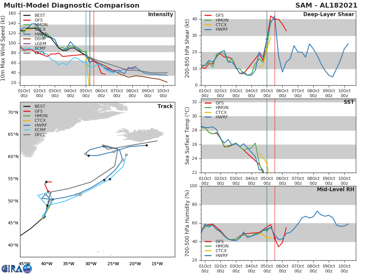
Forecast Track
Time of Latest Forecast: 2021-10-05 06:00
| Forecast Hour | Latitude | Longitude | Intensity |
| 0 | 50.0 | 320.5 | 70 |
| 12 | 52.1 | 321.1 | 65 |
| 24 | 52.8 | 324.9 | 60 |
| 36 | 54.3 | 330.0 | 55 |
| 48 | 57.9 | 335.4 | 50 |
| 72 | 62.7 | 332.6 | 45 |
| 96 | 61.7 | 333.8 | 40 |
| 120 | 63.6 | 345.0 | 40 |
Track History
| Synoptic Time | Latitude | Longitude | Intensity |
| 2021-10-05 06:00 | 50.0 | -39.3 | 70 |
| 2021-10-05 00:00 | 46.3 | -40.7 | 75 |
| 2021-10-04 18:00 | 43.8 | -43.6 | 80 |
| 2021-10-04 12:00 | 41.4 | -47.1 | 85 |
| 2021-10-04 06:00 | 39.9 | -49.9 | 90 |
| 2021-10-04 00:00 | 38.7 | -52.2 | 90 |
| 2021-10-03 18:00 | 38.0 | -53.8 | 85 |
| 2021-10-03 12:00 | 37.3 | -55.4 | 85 |
| 2021-10-03 06:00 | 36.8 | -56.6 | 90 |
| 2021-10-03 00:00 | 35.9 | -57.7 | 105 |
| 2021-10-02 18:00 | 34.8 | -58.7 | 110 |
| 2021-10-02 12:00 | 33.3 | -59.8 | 115 |
| 2021-10-02 06:00 | 32.1 | -61.0 | 115 |
| 2021-10-02 00:00 | 30.7 | -61.5 | 125 |
| 2021-10-01 18:00 | 29.2 | -61.9 | 130 |
| 2021-10-01 12:00 | 27.6 | -61.7 | 130 |
| 2021-10-01 06:00 | 25.8 | -61.6 | 130 |
| 2021-10-01 00:00 | 24.3 | -61.0 | 125 |
| 2021-09-30 18:00 | 23.0 | -60.4 | 125 |
| 2021-09-30 12:00 | 22.1 | -59.5 | 125 |
| 2021-09-30 06:00 | 21.0 | -58.8 | 125 |
| 2021-09-30 00:00 | 20.3 | -58.0 | 125 |
| 2021-09-29 18:00 | 19.8 | -57.3 | 115 |
| 2021-09-29 12:00 | 19.1 | -56.6 | 115 |
| 2021-09-29 06:00 | 18.6 | -55.9 | 115 |
| 2021-09-29 00:00 | 18.1 | -55.3 | 120 |
| 2021-09-28 18:00 | 17.7 | -54.7 | 115 |
| 2021-09-28 12:00 | 17.3 | -54.0 | 115 |
| 2021-09-28 06:00 | 17.0 | -53.6 | 115 |
| 2021-09-28 00:00 | 16.5 | -52.9 | 105 |
| 2021-09-27 18:00 | 16.0 | -52.4 | 105 |
| 2021-09-27 12:00 | 15.4 | -51.7 | 110 |
| 2021-09-27 06:00 | 15.0 | -51.1 | 120 |
| 2021-09-27 00:00 | 14.5 | -50.6 | 130 |
| 2021-09-26 18:00 | 14.0 | -50.3 | 130 |
| 2021-09-26 12:00 | 13.8 | -50.0 | 125 |
| 2021-09-26 06:00 | 13.7 | -49.4 | 125 |
| 2021-09-26 00:00 | 13.4 | -48.7 | 125 |
| 2021-09-25 18:00 | 13.1 | -48.1 | 115 |
| 2021-09-25 12:00 | 12.8 | -47.2 | 105 |
| 2021-09-25 06:00 | 12.7 | -46.3 | 95 |
| 2021-09-25 00:00 | 12.3 | -45.4 | 85 |
| 2021-09-24 18:00 | 11.9 | -44.3 | 70 |
| 2021-09-24 12:00 | 11.6 | -43.1 | 65 |
| 2021-09-24 06:00 | 11.4 | -41.6 | 65 |
| 2021-09-24 00:00 | 11.1 | -40.3 | 60 |
| 2021-09-23 18:00 | 11.0 | -39.1 | 50 |
| 2021-09-23 12:00 | 10.8 | -37.4 | 40 |
| 2021-09-23 06:00 | 10.4 | -35.7 | 30 |
| 2021-09-23 00:00 | 10.2 | -34.4 | 30 |
| 2021-09-22 18:00 | 10.1 | -33.2 | 30 |
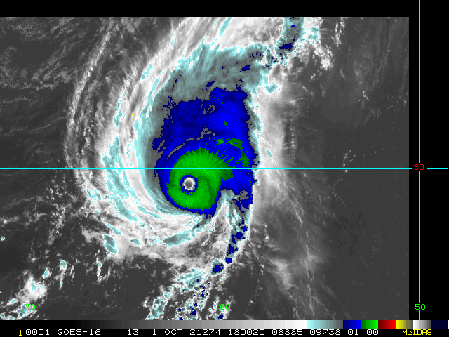
Enhanced Infrared (IR) Imagery (4 km Mercator)

Loop | Latest Image | Archive | About
Time of This Image: 2021-10-01 18:00
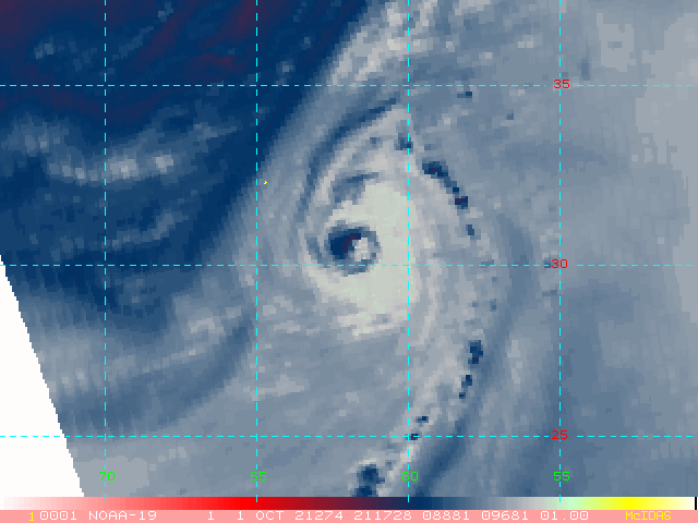
AMSU Microwave 89 GHz Imagery (4 km Mercator)

Loop | Latest Image | Archive | About
Time of This Image: 2021-10-01 21:17
Multiplatform Satellite Surface Wind Analysis (Experimental)

Latest Image | Archive | About
Time of This Image: 2021-10-05 15:00
Ocean Heat Content & Forecast Track
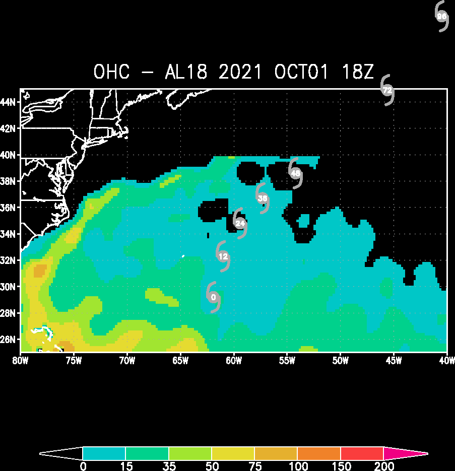
Latest Image | Archive | About
Time of This Image: 2021-10-01 18:00

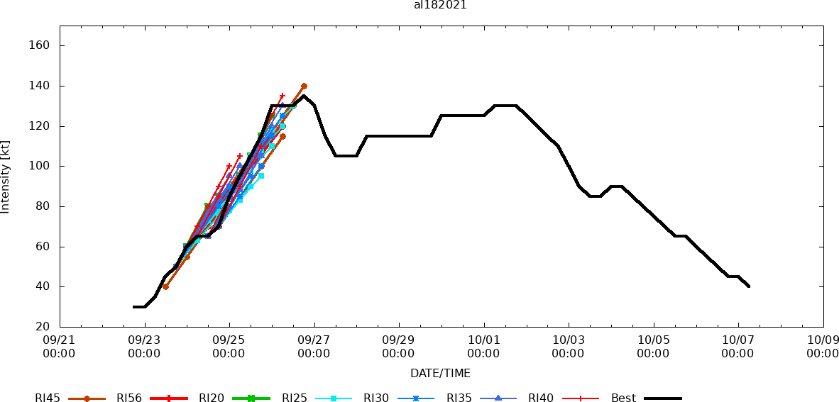
RIPA Storm Table
Please use the links below to view the text data for this product.
Latest Text File | | Archive | About
Time of This Image: 2021-10-05 06:00